Copyright 1998 N. Muller
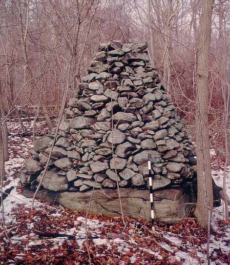
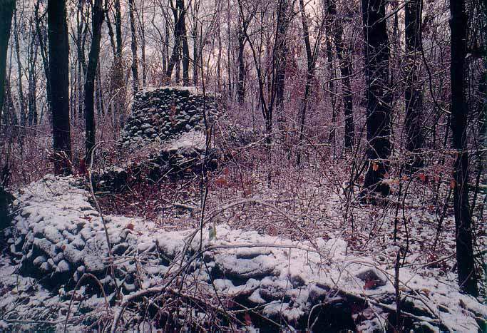
Fig. 1. Cairn "C" looking west. Scale gauge is 1 meter.
Southwest of Allentown, Pennsylvania, on a wooded forty-plus acre ridge site in the Oley Hills, is an impressive and unusual array of manmade stone features that bears little relationship to any known colonial workmanship or activity. These features consist of large and intricately constructed cone-shaped and flat-topped cairns, oddly shaped stone rows, stone platforms, a large stone terrace and ritualized boulders, made by either connecting them with short stone rows, or else by piling small rocks on top of or against them. The workmanship of many of these features is truly artistic and awe inspiring.
The area in which the features occur was home to the Leni Lenapi of the Algonqian Nation long before european settlers appeared. By treaty with the heirs of William Penn in 1732, the native inhabitants relinquished title to the land and moved westward. In their place came German immigrants, who began to purchase land in the form of. Warrants beginning in the mid-eighteenth century. Two families originally owned the forty-plus acres, and plotting their land against existing stone walls reveals only one wall that is contiguous with their property lines; the other walls, of which there are many, do not coincide with them. The lack of old cart paths on the property, pointed out to us by Dr. Michael Stewart, an archaeologist at Temple University, implies that the stones comprising the features had to be transported by hand to the various locations, a considerable undertaking. We are presently researching old deeds, wills and local history in an attempt to learn more about the history of the site and its inhabitants. Today, three different families own portions the forty-acre parcel, and they wish to restrict access to it. We are in accord with their wishes. However, by posting images of some of the features found there, we hope to learn whether similar structures have been found elsewhere in the Northeast. A brief description of five of them follows. All features are of dry masonry construction. With the exception of some cobbles of quartz incorporated in the features, all of those described in this report are constructed of gneiss, a native rock. Cobbles of quartz have yet to be found in the area apart from the stone features.
At the base of the ridge are four, intricately constructed, cone-shaped cairns heavily encrusted with lichen. All are built on existing flat-topped boulders. The one pictured below (Fig. 1) is 1.3m high and 1.5m wide, on a boulder .7m high.
Because the base boulder is oval, the cairn looks pinched as viewed from the side. Nearby is a similarly constructed cone-cairn 3m high, built on a round boulder 1m high.
In the fall and winter of 1997-98, Muller and Waltz surveyed the Central Ridge site and produced a map, which is included in part as Fig. 2. Changes in terminology have been noted in the text herein describing certain features. The numerous small crosses (+) indicate small rude 'cairns'.
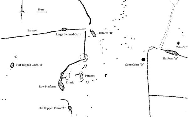
Halfway up the ridge, on a flat plateau, is a rectangular stone platform (Platform "B"), measuring 6.7m x 3.3m, and between 1 and 2m high. Two other platforms have been found on the site, one to the east and the other to the west. Platform "B" is deemed important because of the fact that three separate stone rows diverge no more than 3m from it, each oriented along one of the main compass points. The row to the west seems to emerge from the ground and soon meets a Large Inclined Cairn, 1.9m high and 4.5m long, constructed on and against a large boulder. The north row does not engage a boulder but simply curves and traces the ridge crest. Interestingly, it has an unusual wedge-shaped cross-section, with its vertical face being oriented to the east, and the tapered west-facing side consisting of a backfill of large and small flat stones. A similarly constructed row continues to the south, departing near the platform. It climbs up and over a rounded ledge or boulder, and then abruptly turns to the west. At this point the shape of the row changes, assuming a rounded cross-section and becoming flat on top. This row then curves up the slope to the south, looping to the west of a large, egg-shaped boulder (labeled "Erratic" on the map), 3m high and 4m long, on the flat-to-gently sloping summit, and ending in a wide Row-Platform to its south-west. (Fig.3). We feel that this boulder is the heart of the area that we call the Central Ridge.
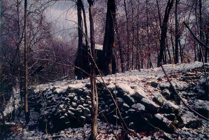
About 6m to the east and on the opposite side of the large boulder from the Row-Platform is a flat-topped, curved feature that we call the Terrace (Fig. 4 -- labeled "Parapet" on the map). It is approximately 2.5m high and 12.7m long and projects 2m outward from the ridge crest. From the Terrace the site slopes to the east, dropping 16m in 65m (25%) and then more gradually, overlooking most of the previously mentioned features and the valley below. The larger cobbles of gneiss are covered with smaller stones that we call paving stones, undoubtedly to create a surface suitable for standing. Similar small stones are found on two of the platforms and the row-platform mentioned above. The proximity of the terrace to the large boulder and the row that curves around it implies that its function is somehow tied in with them, although we are unsure what this might be.
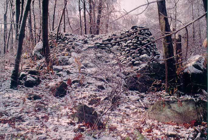
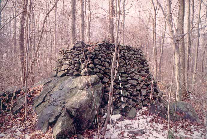
Just south of the large boulder, not more than fifteen meters away, is a curved stone row that merges with an unusual looking, flat-topped cairn (Fig. 5). Like the row that emerged from the ground in front of Platform "B," this has a similar appearance, being .7m high and very compactly constructed. It is one of many such unusual rows found at the site.
From the side, one can see that this cairn, as with all the others, is built against a large boulder, which is an integral part of it (Fig. 6). Cobbles of gneiss, 20-30cm across, comprise most of the structure, with smaller pieces wedged in between. The cairn is 2.1m high and c.2.4m long, contiguous with a boulder 1.5m high.
In our study of the features on the site, we have observed the following characteristics about them:
Norman Muller (nemuller5@gmail.com)
John Waltz (jwaltz@aol.com)